
|


This example is for Wiring version 1.0 build 0100+. If you have a previous version, use the examples included with your software. If you see any errors or have comments, please let us know.
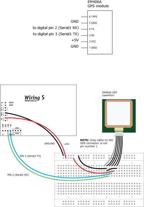
This example illustates basic use of the NMEA library. It assumes that a GPS receiver is connected to serial port 'Serial1' at 4800 bps, LEDs are connected to digital i/o pins 8 and 9
A GPS data connection of type GPRMC is created, and used to get position information. When the GPS position is in the state of Colorado (USA), the LED lights up, otherwise it is off.
A GPS data connection of type GPRMC is created, and used to get position information. When the GPS position is in the state of Colorado (USA), the LED lights up, otherwise it is off.
#include <nmea.h>

NMEA gps(GPRMC);  // GPS data connection to GPRMC sentence type
float d;          // relative direction to destination

// destination coordinates in degrees-decimal
float dest_latitude = 48.858342;
float dest_longitude = 2.294522;

void setup() {
  Serial1.begin(4800);
  pinMode(8, OUTPUT);
  pinMode(9, OUTPUT);
}

void loop() {
  if (Serial1.available() > 0 ) {
    // read incoming character from GPS
    char c = Serial1.read();

    // check if the character completes a valid GPS sentence
    if (gps.decode(c)) {
      // check if GPS positioning was active
      if (gps.gprmc_status() == 'A') {
        // calculate relative direction to destination
        d = gps.gprmc_course_to(dest_latitude, dest_longitude) - gps.gprmc_course();
        if (d < 0) { d += 360; }
        if (d > 180) { d -= 360; }
        // set LEDs accordingly
        if (d < 5) {
          digitalWrite(8, HIGH);
        } else {
          digitalWrite(8, LOW);
        }
        if (d > -5) {
          digitalWrite(9, HIGH);
        } else {
          digitalWrite(9, LOW);
        }
      }
    }
  }
}